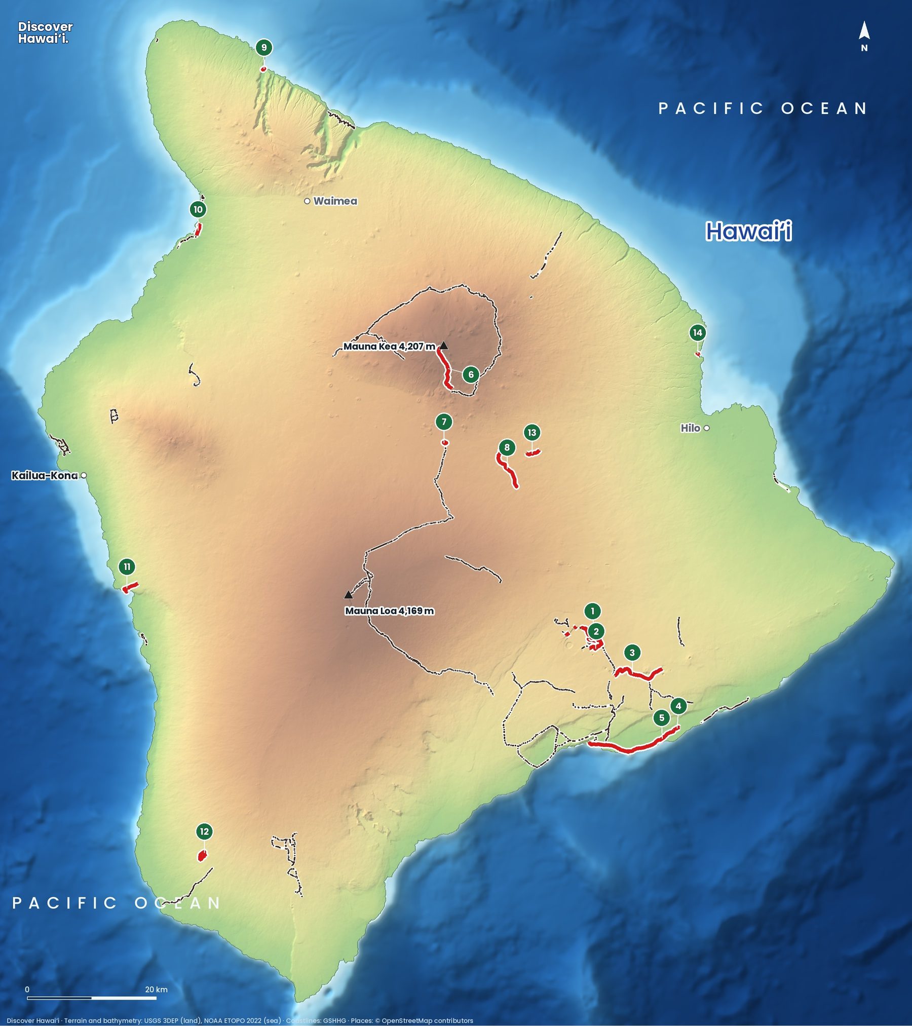
The Big Island has every kind of hike Hawaii can offer: across a lava lake that was boiling in 1959, up the highest mountain in the Pacific, down to a black-boulder beach in a jungle valley, and along the old coastal footpaths of the Kohala coast. Here are 14 featured trails on one map.
Trail status · October 2026
Kīlauea's summit has been restless in 2026. In October the National Park Service closed the Halemaʻumaʻu Trail and part of the Byron Ledge Trail because of earthquakes and rockfall risk, and the connection from Kīlauea Iki to the caldera floor is closed; the main Kīlauea Iki loop (1) was open. Parts of the Crater Rim Trail (2) have been closed since the 2018 summit collapse. Pololū Valley (9) was open. Check the park's current conditions on the day.
Where are the best hikes on the Big Island?
The biggest cluster is in Hawaiʻi Volcanoes National Park, around the summit of Kīlauea and down the Chain of Craters Road to the sea. The Saddle Road between Mauna Kea and Mauna Loa has high-altitude hikes in cool air. The Kona and Kohala coasts have sunny shoreline trails, and the wet Hāmākua and Hilo side has rainforest and the dramatic valleys of the north.
- Kīlauea Iki TrailModerate3.3 mi (5.3 km) loop Across a lava lake crater from 1959, Hawaiʻi Volcanoes National Park.
- Crater Rim Trail (open sections)Moderate5.8 mi (9.3 km) Parts have been closed since the 2018 summit collapse.
- Nāpau TrailDifficult5.9 mi (9.5 km) Past the Mauna Ulu lava fields. Backcountry permit to camp.
- Puʻu Loa PetroglyphsEasy0.6 mi (1 km) A boardwalk to more than 23,000 rock carvings.
- Puna Coast TrailDifficult9.5 mi (15.3 km) A remote lava coast. Hot, with no water.
- Mauna Kea–Humuʻula TrailDifficult6 mi (9.7 km) From the Visitor Station to the summit: 1,400 m of climbing at high altitude.
- Puʻu Huluhulu TrailEasy1 mi (1.6 km) A cinder cone on Saddle Road with views of both giants.
- Puʻu ʻŌʻō Trail (Saddle Road)Moderate3.7 mi (6 km) Native forest kīpuka, great for birding.
- Pololū Valley TrailModerate0.5 mi (0.8 km) Steep switchbacks to a black-boulder beach.
- Ala Kahakai: Hāpuna–PuakōModerate3.8 mi (6.1 km) An ancient coastal footpath along the Kohala beaches.
- Captain Cook Monument TrailDifficult1.9 mi (3.1 km) A steep 400 m descent to Kealakekua Bay, and a hard climb back.
- Manukā Nature TrailEasy2.1 mi (3.4 km) loop A forest loop in the south, in Kaʻū.
- Kaūmana TrailEasy1.5 mi (2.4 km) Rainforest on an 1881 lava flow above Hilo.
- Onomea (Donkey) TrailEasy0.6 mi (1 km) A Hāmākua coast path down to Onomea Bay.
What are the best hikes in Hawaiʻi Volcanoes National Park?
The Kīlauea Iki Trail (1) is the best day hike in the park and one of the best in the United States. It drops through rainforest on the crater rim, then crosses the floor of Kīlauea Iki, a lava lake that formed during the 1959 eruption, when fountains shot about 1,900 feet into the air. The surface is still cracked and steaming in places. Allow two to three hours and stay on the marked route across the crater floor.
The Crater Rim Trail (2) once circled the whole summit caldera; since the collapse of 2018 only some sections are open. Further down the Chain of Craters Road, the Nāpau Trail (3) crosses the lava fields of Mauna Ulu, and a short boardwalk leads to Puʻu Loa (4), a field of more than 23,000 petroglyphs, many of them holes where families placed a newborn's umbilical cord. Never step on the carvings. The Puna Coast Trail (5) is a long, exposed walk on bare lava for experienced hikers only.
Can you hike Mauna Kea?
Yes, but it is a serious undertaking. The Humuʻula Trail (6) climbs from the Visitor Information Station at about 9,200 feet to the 13,796-foot summit, gaining around 4,600 feet in six miles. Altitude sickness is common, the weather can turn to snow, and you should not go up within 24 hours of scuba diving. Mauna Kea is also deeply sacred to Native Hawaiians, so treat the summit with respect.
For an easier taste of the high country, Puʻu Huluhulu (7) is a short climb up a forested cinder cone on Saddle Road, with views of Mauna Kea and Mauna Loa. Nearby, the Puʻu ʻŌʻō Trail (8) crosses old lava to kīpuka, islands of native forest that the lava flowed around, where rare Hawaiian forest birds still live.
Can you hike to the Captain Cook Monument?
Yes. The Captain Cook Monument Trail (11), also called the Kaʻawaloa Trail, drops about 1,300 feet in under two miles to the shore of Kealakekua Bay, where Captain James Cook was killed in 1779. The monument is on the bay's north shore, and the snorkeling in front of it is some of the best in Hawaii. The trail is hot and rocky and the climb back out is hard, so start early and carry at least two litres of water each.
What are the best coastal hikes?
In North Kohala, the Pololū Valley Trail (9) zigzags down from the end of the road to a black-boulder beach backed by cliffs and ironwood trees. It is short but steep and slippery after rain, and the surf is too rough for swimming. On the Kohala coast, the Ala Kahakai (10) follows part of an ancient Hawaiian footpath between Hāpuna and Puakō, past tide pools and petroglyphs; it is now a National Historic Trail. On the Hilo side, the old Onomea "Donkey" Trail (14) leads down to a small bay on the Hāmākua coast.
What are the best easy hikes on the Big Island?
Pick Puʻu Loa (4) for petroglyphs, Puʻu Huluhulu (7) for a quick summit, or the Manukā Nature Trail (12) for a forest loop in Kaʻū. Above Hilo, the Kaūmana Trail (13) wanders through rainforest that has grown on a lava flow from Mauna Loa's 1880–81 eruption, which stopped just short of town.
A few rules apply on every island. Start early, because clouds and rain build over the mountains by midday. Carry more water than you think you need, wear shoes with grip, and turn around if a stream is rising: flash floods in Hawaii can arrive with no rain where you are standing. Stay on the trail and off closed or private land, and leave rocks, plants and anything at heiau (temple sites) exactly where you found them.
For more, see the Big Island guide, our map of the Big Island's volcanoes and lava flows and the Big Island snorkel and dive map.
Facts checked October 2026. Trails close after storms, rockfalls and volcanic activity, so check the official status page and the weather before you go.
- National Park Service: Uncertainty at Kīlauea summit prompts safety closures (7 Oct 2026)
- National Park Service: Hawaiʻi Volcanoes National Park
- USGS Hawaiian Volcano Observatory
- National Park Service: Ala Kahakai National Historic Trail
- Nā Ala Hele: Hawaiʻi Trail & Access System (DLNR)
- Map data: Hawaiʻi DLNR Nā Ala Hele trail system, U.S. National Park Service, USGS 3DEP, NOAA ETOPO 2022, GSHHG, © OpenStreetMap contributors