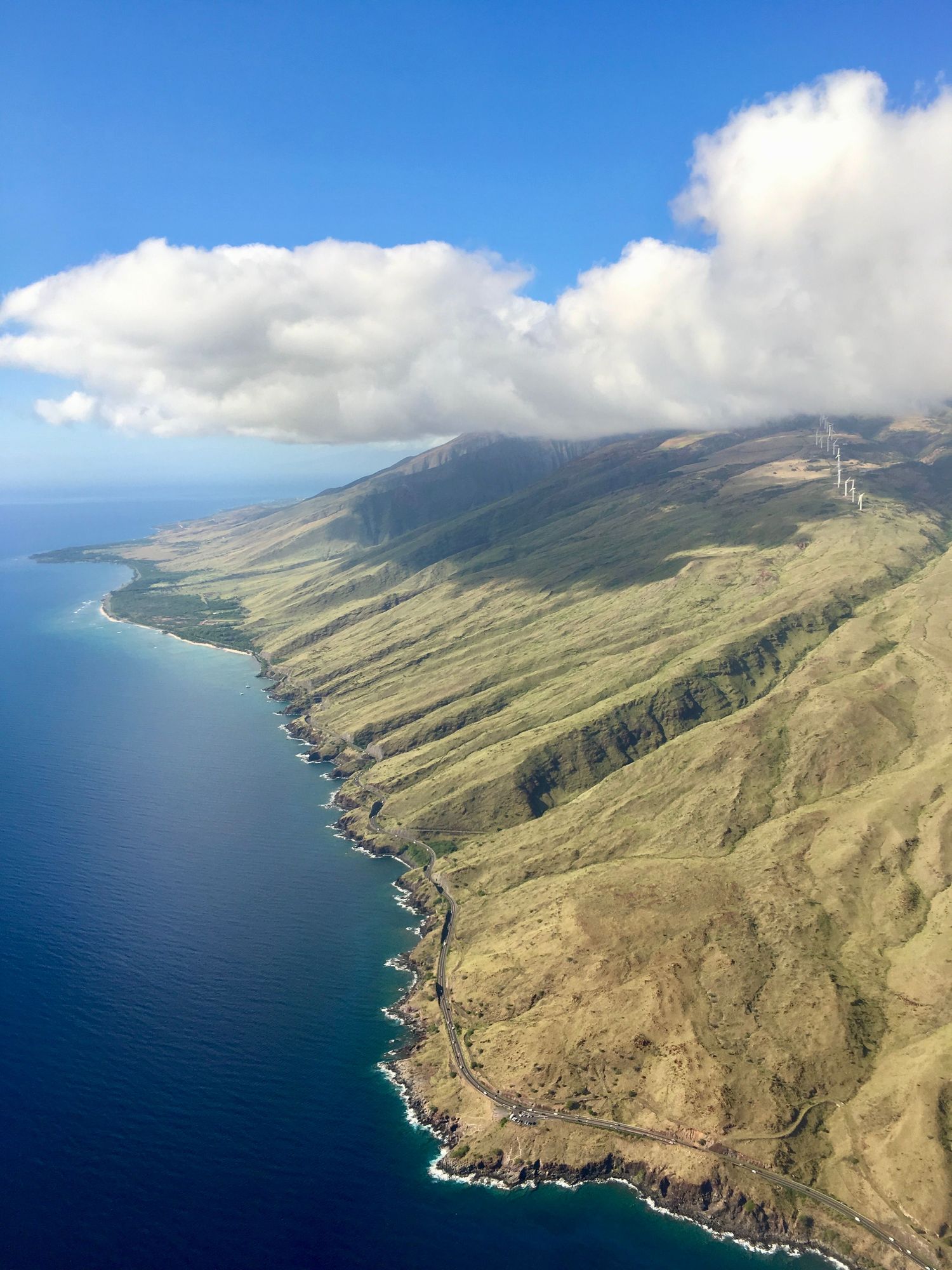
On Maui you can start the day above the clouds at 10,000 feet, walk down into a volcanic crater that looks like another planet, and finish it in a bamboo forest beside a 400-foot waterfall. Add Molokaʻi and Lānaʻi across the channels, and you have 14 featured trails on one map.
Trail status · October 2026
Most Maui trails are open. After storm damage in 2026, Polipoli Spring State Recreation Area (the Redwood Trail, 11, and the lower Skyline Trail, 10) remained closed, and the Makawao, Kula and Waihou forest reserves (including Kahakapao, 9) were closed in early October; check before you go. At Kīpahulu, the Pīpīwai Trail is open but restrooms and water stations were closed for repairs. Sources: Hawaiʻi State Parks, Haleakalā National Park.
Where are the best hikes on Maui?
Maui is two volcanoes joined by a low isthmus. The big one, Haleakalā, has the summit trails, the upcountry forests of Makawao and Kula, and Kīpahulu on the far side of the Road to Hāna. The older West Maui Mountains have steep ridges and waterfall valleys. Across the channels, Molokaʻi has the most dramatic historical hike in Hawaii, and Lānaʻi a quiet coastal trail to Sweetheart Rock.
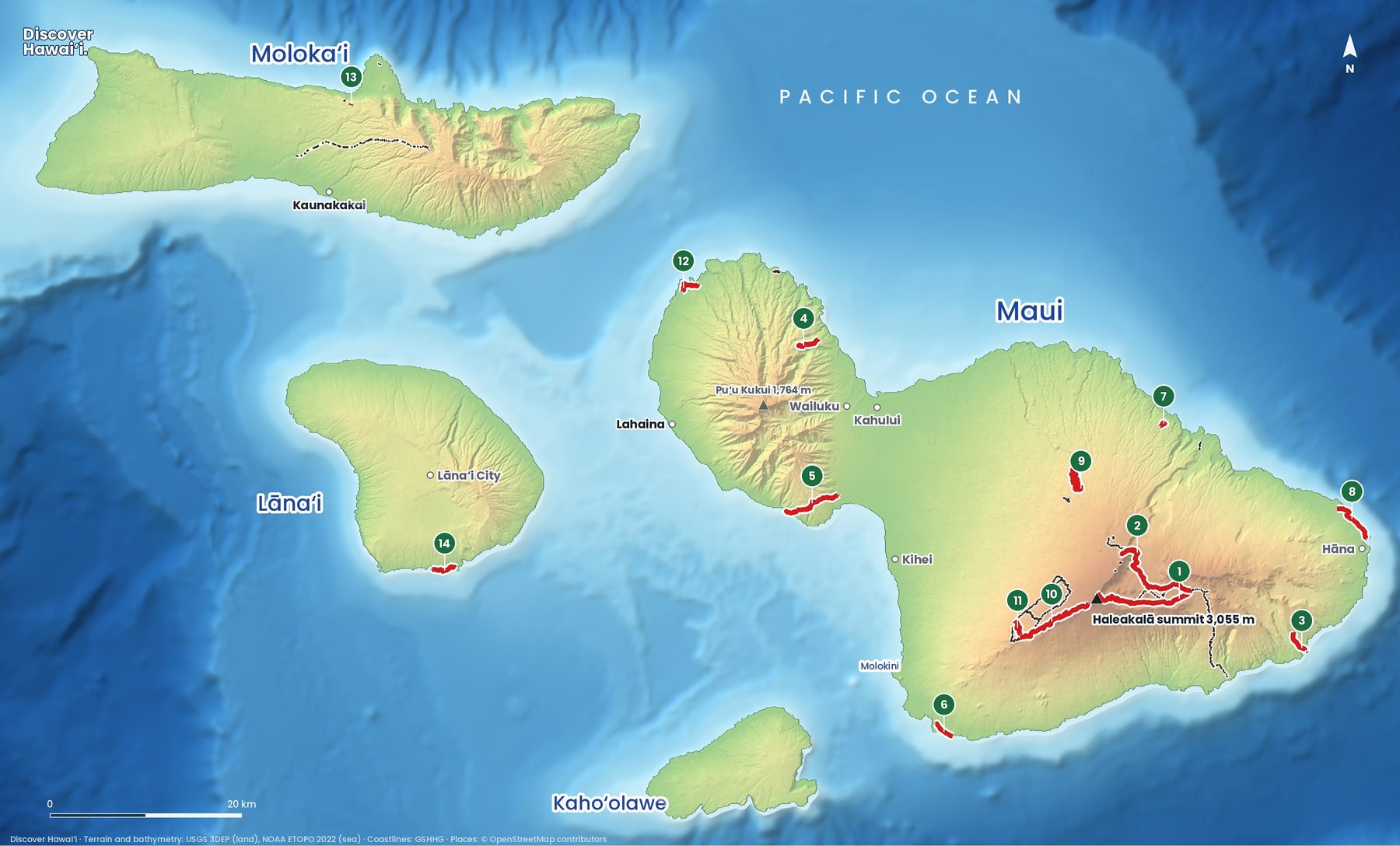
- Keoneheʻeheʻe (Sliding Sands) TrailDifficult7.8 mi (12.6 km) one way From the Haleakalā summit down into the crater. Thin air at 3,000 m.
- Halemauʻu TrailDifficult8.8 mi (14.2 km) Crater switchbacks to the Hōlua cabin and beyond.
- Pīpīwai TrailModerate1.6 mi (2.6 km) one way Kīpahulu: through a bamboo forest to the 400-foot Waimoku Falls.
- Waiheʻe Ridge TrailModerate2.5 mi (4 km) A West Maui ridge with waterfall views.
- Lahaina Pali TrailDifficult5.5 mi (8.8 km) An old horse trail over the West Maui slopes. Hot, no shade.
- Hoapili (King's) TrailDifficult12.5 mi (20.1 km) A historic lava-rock path past La Pérouse Bay.
- Waikamoi Ridge TrailModerate0.8 mi (1.3 km) A short forest loop on the Road to Hāna.
- Ke Ala Loa o Maui / Piʻilani TrailModerate1.5 mi (2.4 km) The Waiʻānapanapa coastal path. Park reservation needed.
- Kahakapao Loop (Makawao Forest)Moderate5.4 mi (8.7 km) loop An upcountry forest loop shared with mountain bikes.
- Skyline TrailModerate6.8 mi (10.9 km) From the Haleakalā summit ridge down to the Polipoli forest.
- Redwood Trail (Polipoli)Moderate1.7 mi (2.7 km) Misty redwood and cedar forest in Kula.
- Kapalua Coastal TrailEasy1.7 mi (2.7 km) Bays and lava points between Kapalua and D.T. Fleming Beach.
- Kalaupapa Pali Trail, MolokaʻiDifficult3 mi (4.8 km) Guided National Park Service hikes only, booked on recreation.gov, age 16+.
- Hulopoʻe–Huawai Fishing Trail, LānaʻiDifficult1.75 mi (2.8 km) A sea-cliff path near Puʻu Pehe (Sweetheart Rock).
Can you hike into Haleakalā Crater?
Yes, and it is unforgettable. The Sliding Sands Trail (1), Keoneheʻeheʻe in Hawaiian, starts at the summit visitor centre at about 9,700 feet and drops into a vast landscape of red and black cinder cones. The Halemauʻu Trail (2) comes in from the other side, down switchbacks on the crater wall. Hikers with two cars walk down Sliding Sands and out on Halemauʻu, a full day of about 11 miles.
Remember that every step down is a step you have to climb back up, at high altitude. The air is thin, it can be freezing at dawn and very hot by midday, and there is no water on the trail. Haleakalā National Park charges an entrance fee, and you need a separate advance reservation to drive up for sunrise. Do not drive to the summit within 24 hours of scuba diving.
Is the Pīpīwai Trail worth it?
Yes. The Pīpīwai Trail (3) is in the Kīpahulu district of Haleakalā National Park, near the end of the Road to Hāna. It climbs past a giant banyan tree, through a bamboo forest that creaks and knocks in the wind, to the base of Waimoku Falls, which drops about 400 feet down a sheer rock wall. Plan two to three hours and wear shoes you do not mind getting muddy. Your national park entrance receipt covers both Kīpahulu and the summit for three days. The ʻOheʻo pools below the trail were closed to swimming in 2026.
On the way, Waikamoi Ridge (7) is a short forest loop that breaks up the drive, and the coastal Ke Ala Loa o Maui (8) at Waiʻānapanapa State Park follows a black lava coast past sea arches and blowholes. Non-residents need an advance reservation to enter Waiʻānapanapa.
What are the best hikes in West Maui?
The Waiheʻe Ridge Trail (4) is the best short hike in West Maui: a steep, steady climb up a ridge above the Waiheʻe Valley, with waterfalls on the far wall and views down to the north coast. Go early, before the clouds settle on top. At the other end of the scale, the Kapalua Coastal Trail (12) is an easy walk between bays and lava points, good at sunset and in whale season.
Two historic trails cross dry, hot country. The Lahaina Pali Trail (5) is an old horse trail over the southern flank of the West Maui Mountains, with views over Māʻalaea Bay and Kahoʻolawe. The Hoapili Trail (6), also called the King's Trail, is part of an old route that once circled the island; it crosses young lava fields beyond La Pérouse Bay. Start both at dawn and carry plenty of water.
Can you hike on Molokaʻi and Lānaʻi?
Yes. On Molokaʻi, the Kalaupapa Pali Trail (13) drops about 1,700 feet down some of the highest sea cliffs in the world, in 26 switchbacks, to the Kalaupapa peninsula. From 1866, people with Hansen's disease (leprosy) were forcibly isolated there, and the settlement is now a National Historical Park. Since July 2026, the only way to visit has been a guided National Park Service hike, booked on recreation.gov up to 30 days ahead, limited to small groups aged 16 and over. You hike down and back up the same day.
On Lānaʻi, the Fishing Trail (14) runs along the sea cliffs from Hulopoʻe Bay towards Puʻu Pehe, the sea stack known as Sweetheart Rock. The cliffs are high and unfenced, so keep children close. Kahoʻolawe, the fourth island on the map, is closed to the public.
When is the best time to hike Maui?
Any month works. Summer is drier, but West Maui and the windward coast are green and wet all year, and Haleakalā's summit can be cold at any time. Winter brings humpback whales into the channels, which you can often spot from the coastal trails. Start early on every trail: by late morning, clouds usually build over the mountains and the dry coasts get very hot.
A few rules apply on every island. Start early, because clouds and rain build over the mountains by midday. Carry more water than you think you need, wear shoes with grip, and turn around if a stream is rising: flash floods in Hawaii can arrive with no rain where you are standing. Stay on the trail and off closed or private land, and leave rocks, plants and anything at heiau (temple sites) exactly where you found them.
See the Maui island guide, the Molokaʻi and Lānaʻi guides, and our Maui snorkel and dive map.
Facts checked October 2026. Trails close after storms, rockfalls and volcanic activity, so check the official status page and the weather before you go.
- National Park Service: Haleakalā permits and reservations
- National Park Service: Kalaupapa National Historical Park
- Hawaiʻi Public Radio: National Park Service launches Kalaupapa hiking tour (July 2026)
- Hawaiʻi State Parks: Polipoli Spring State Recreation Area
- Nā Ala Hele: Hawaiʻi Trail & Access System (DLNR)
- Map data: Hawaiʻi DLNR Nā Ala Hele trail system, U.S. National Park Service, USGS 3DEP, NOAA ETOPO 2022, GSHHG, © OpenStreetMap contributors